Get Lost Mountaineering
You are here: England » Pennine Way » 1. Edale Village to Hebden Bridge
4: Standedge to White House crossing the A640, A672 and M62 via Pennine Way
4: Standedge to White House crossing the A640, A672 and M62 via Pennine Way
Start/Finish
Standedge car park on the A62 Oldham to Huddersfield road at SE 020 095 about 8 miles east of Oldham. There are prominent signs saying the Pennine Way is crossing the A62 at this point. There is a reasonably sized car park which is free.
Distance/Time
13 km. About 4 – 5 hours.
Peaks
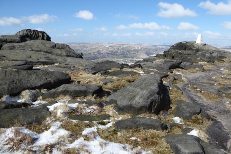
Millstone Edge Trig Point, 448 m, SE 012 104.
White Hill Trig Point, 466 m, SD 990 132.
Blackstone Edge Trig Point, 472 m, SD 972 163.
OS Outdoor Leisure 1: Dark Peak. OS Outdoor Leisure 21: South Pennines.
Introduction
The South Pennines now take over from the Peak District. This is a fine walk with no real hills and no difficult ground. It is mainly high moorland with views of edges and reservoirs. Unusually, the Pennine Way crosses the M62 motorway by a footbridge high over the motorway. There isn't a particularly high fence on the bridge and it can be a bit unnerving in high winds. As the bridge is close to junction 22, it is possible to use the non-motorway roads to get across but expect a diversion of at least a mile! Signage is not particularly good after crossing the M62. The White House is a pub restaurant which is very popular in the locality despite its rather isolated position high above Littleborough. This section crosses 3 main roads so there are plenty of options to meet a support team.
Route
(1) Cross the road from Standedge car park and follow the Pennine Way (signed) north. Strangely, the Pennine Way is not signed at the next few signs so continue straight ahead at these. Note that you are following the Pennine Way and not the Pennine Bridleway which takes a different route. About 1 km from the start reach the Millstone Edge Trig Point, 448 m. Continue along the edge to reach a dip where the Pennine Way goes right, N, at a small stone sign. Follow this to reach the A640 main road from Oldahm to Marsden and Huddersfield.
(2) Cross over and continue on the signed Pennine Way. After about 2 km, reach the White Hill Trig Point, 466 m. Continue for about another 2 km to reach the A672 main road from Denshaw to Ripponden at SD 982 142, a few hundred metres south west of the motorway junction. On a clear day, the M62 will now be visible as well as being heard!
(3) Cross the road then the large rough car park and continue on the Pennine Way, which starts near a flat stone, for about 600 m, passing a mast, to reach the footbridge over the M62 and cross over. Cross the footbridge and reach a sign. Go left, W, here and follow the rough track which, surprisingly, is not signed as the Pennine Way. Follow the track/path which is slabbed in places and soon swings NNW, crossing a minor clough, (gully) before making a long gradual ascent up towards Blackstone Edge. Once the angle eases, a large shelter cairn is passed. Continue, gradually converging with the edge on the left. Reach the trig point which sits on a boulder and may be awkward to reach when the rock is slippery. This is Blackstone Edge Trig Point, 472 m.
(4) Continue along the edge. The path is not as well defined as earlier but it leads to a fence and sign where one goes left which is signed as the Pennine Way. This descends gradually to reach a “crossroads”, near a gate. Go right here – not signed. Follow the curving track around the W side of Blackstone Edge Moor. Pass a “concrete plank” bridge. Continue to reach a wider “concrete bridge”. On the right is an old quarry. On the left, a track descends to the road. This track is the Pennine Way so follow it down to the road then walk up the road to the White House.
Notes
(a) This is a composite route compiled from walks which took place on 23rd February, 2018, and 19th March, 2018.
Photos - Hover over photo for caption. Click on to enlarge. Click on again to reduce.